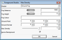
Ground Fog
Ground Fog
Simulates a layer of fog whose density decreases with altitude.

Fog Distance: Alters rate at which the fog density increases with distance from the viewer; lower values will make the fog dense more quickly.
o Default: 1000.
o Range: 0 – Infinite.
Fog Height: The height of the fog.
o Default: 0.0
o Range: -Infinite - +Infinite
Fog Color: The color of the fog.
o Default: White.
o Range: RGB color.
Ground Point: A point on the ground plane.
o Default: 0,0,0
o Range: Cartesian coordinates
Ground Normal: The normal to the ground plane
o Default: 0,0,1
o Range: Cartesian coordinates.
Max density: The maximum density of the fog.
o Default: 1.0
o Range: 0.01 – 1.00
Ignore background: Specifies whether background pixels are affected by the fog.
o Default: On.
o Range: On / Off.
|
|