Creating a Terrain Model
Home > 24 Terrain > Creating a Terrain Model
Creating a Terrain Model
Create a topographic map or model.
\terra
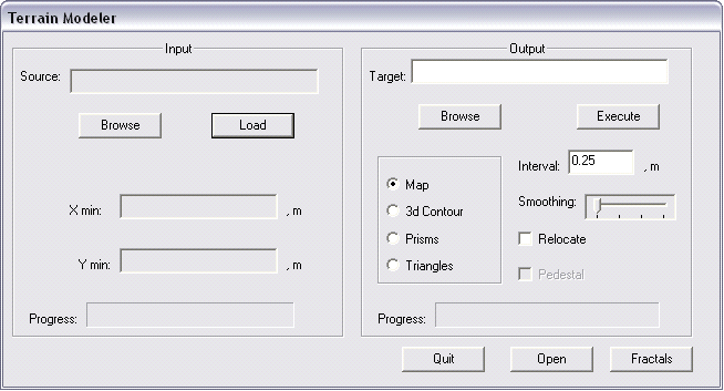
To create a topographic model file, enter the data in the input and output sections in the Terrain Modeler dialog box. The dialog box is described below.

To view an existing topographic model, use the Open a file (\open) command.
The size of your file is affected by the height interval between each contour line and the smoothing factor. Smoothing factors are described below.
The dialog box contains two sections: input and output.
INPUT
Indicate the type of source file.
Enter the path and name of your source file in the source field. The file extension is not required. To search for a path press the browse button.
Press load to load the file.
OUTPUT
Once the file is loaded, enter the name and path of the model file in the TARGET field.
You may relocate the original coordinates of a map imported to ARC+. The original X Y minimum coordinates are shown in the input section. To relocate the lower left corner of the original map to the ARC+ origin point, select the relocate button.
Choose a topographic map or model type from the model type section. The different types are described below.
You may add a base to triangulated models by choosing the pedestal option. Once the base is added, the model becomes a complex solid and may be modified using Boolean and sectioning operations.
Enter the required height interval in meters between each contour line in the interval field. The default is 0.25 meters. This option is not applicable to triangulated network models.
Enter a smoothing factor from the smoothing field. Contour smoothing is described below. This option is not applicable to triangulated network models.
Press execute to create the file.
Open the model file as you would open any ARC+ file.
 HINT If your topographic model appears distorted, perform the following troubleshooting procedure. Check your TERRA.RPT file for identical X Y coordinates. Models are single valued functions of the variables X Y. This means that no part of the model may be overhanging or exactly vertical, causing it to have more than one Z value at any specific point.
