Latidude/Longitude Map (Panorama)
Latidude/Longitude Map (Panorama)
Define an environment using a single panoramic image.
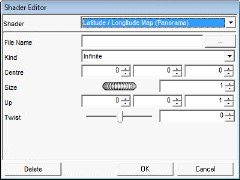
File Name: A suitable image to place in the face cube background.
o The valid file types are Tiff, TGA, BMP, JPG, EPIX, LWI, HDR, EXR and PNG.
Kind: Specify whether environment will be fixed distance or infinite.
o Default : Infinite.
o Range: Infinite / Fixed
Centre: The centre of the environment (fixed environment only).
o Default : 0,0,0.
o Range: Cartesian coordinates
Size: The size of the environment (fixed environment only.
o Default : 1.
o Range: 0 - Infinite.
Up: Allows the (possibly rotated) environment to be tilted so that the zaxis matches the "up" vector.
o Default : 0,0,1
o Range: Cartesian coordinates
Twist: Specifies how much the environment has been rotated about the z-axis and the units are degrees.
o Default : 0
o Range: - 180° / +180°
|
|